Drone Photogrammetry for Construction Planning and Control
Drone photogrammetry is designed to provide high-precision images for construction and planning projects.
Using advanced drone technology, it captures detailed aerial images and transforms the obtained data into accurate 3D maps. From these images, precise topographic maps are generated, allowing for exact measurements of areas, volumes, and distances.
This technology has revolutionized the way construction projects are planned and executed by providing fast, reliable, and highly accurate data. It facilitates strategic decision-making at all stages of your project, from land assessment to progress monitoring.
In construction projects, drone photogrammetry is essential for:
Topographic surveys:
It allows to evaluate the terrain before starting the work, identifying slopes, geographic features and other essential details for planning.
Progress monitoring:
It facilitates real-time tracking of construction progress, which helps identify potential delays or problems before they become major complications.
Quality control:
Through the 3D models generated, the results of the work can be compared with the original plans, ensuring that quality standards are met.
What we offer
Our commitment to excellence drives us to provide comprehensive solutions, and in this regard, we offer this service to our clients.
It is important to note that it is only available in cases where we handle the entire process from the initial stage, including preliminary studies, draft projects, construction plans, specifications, and procedures with the Federation of Engineers and Architects of Costa Rica (CFIA).
This ensures a complete understanding of the work to be done, and drone photogrammetry provides the ideal complement to successfully carry out any project.
Our Projects

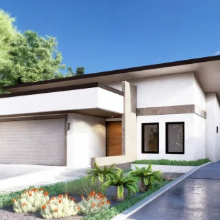
Residential House G2-25
The project has a structure of 350 - 400 m2 of construction, among which

Ojochal WW Residential House
This particular preliminary project was a conceptual proposal assimilating the forms into two triangles

Residential house WB
This preliminary project is a housing model that meets the general requirements of a

Residential house SC
The house was located in a complicated terrain, with height differences with respect to

Residential house NC
This smaller-than-conventional design shows the comforting quality of the space, despite the small square

Residential house Uvita FC
The beach house enjoys a privileged location overlooking the entire bay of Uvita. With
Contact us at
Would you like to undertake a project with us? Contact us, and we will provide you with the best advice.
Error: Contact form not found.